Saturday, September 6, at about 3 pm we backed the Matilda into here space at Fohl Street Storage. a tad less than 10,000 miles driving on this trip (truck miles, less for the trailer). We saw what we had set out to see and then some. The Sangre de Christo Mountains of New Mexico were as we remembered them and are probably in the top five of places to settle with no regrets. The Black Hills of South Dakota may be another spot but a long way from the mecca of internal combustion engines in the Deadwood-Sturgis-Spearfish triangle.
The five day drive home was not too bad. Side winds through South Dakota, Iowa, and Illinois, were a bit of a fight and made for terrible MPG. If nothing else, Sophie the cat is happy to see me back in my rocking chair where she finds a lap. She is, we are sure, happy not to be in the truck.
So ends another expedition and this blog. Sometime before Christmas I may be at it again. Check it out. I will be noting temperatures in the sunny south to help those in the snow feel better.
Monday, September 8, 2014
Sunday, August 31, 2014
Leave only your shadow


Friday, August 29, 2014
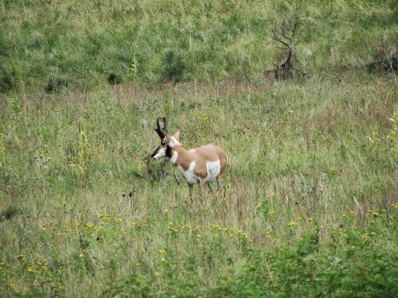
Another visit to Custer State Park

Wednesday, August 27, 2014
1880 TRAIN

For the sake of those who notice such things, this was yesterday's activity. Today was laundry day. I did not see a real need for photographs.
Monday, August 25, 2014


CCC example

Saturday, August 23, 2014
Civilian Conservation Corps

The father of a good friend served in the CCC and the rumor was that this was the reason he could not do carpentry with any wood smaller than a 2X4. These young men built their own camps and then went to clear woods, build bridges, dams, as well as other things. The picturesque stone bridges on park roads may well be a legacy of the CCC.
The organization was quasi-military. Work parties were led by junior military officers to give them command experience they would not get in a small peacetime army. The young men got a job at a time when there was no work. The pay was a dollar a day
and almost all of that was sent to their families to help out in the hard times. The worker got three meals and a "flop" (place to sleep). Camps also had recreation halls and educational programs were provided. An enlistment was for six months and if the experience/training did not provide an opportunity in the outside world, you could reenlist for another six months.

Friday, August 22, 2014
Please be patient.
After being dragged across the coals, demeaned, threatened, and otherwise criticized (all by one person), for not blogging I thought I would offer a feeble excuse. We went to Riverton, Wyoming for 8 days on family (Denise's) business and if you knew Riverton you would understand why there was no reason to photograph or write.
We arrived in the Black Hills of South Dakota yesterday and are now in the trailer hiding from a repetition of downpours. The campground is just south of Deadwood where this weekend is Cool Nites Deadwood. It is a 50s-60s thing with zillions of restored automobiles and bands playing rock music that has no hope of being restored. The area just got rid of the motorcycles and they attracted cars. This is one of the most beautiful NATURAL areas of the country and they bring in noisy, smelly, polluting machines. Isn't our truck enough? They should have stopped after defacing a perfectly good mountain with carved heads of presidents.
Anyway, check back as I can promise there will be pictures of bison (better than cats on Facebook) and more than likely the 1880 Train. With luck maybe something a tad more rare.
Monday, August 11, 2014
The Eagle has Landed, or maybe just about ready to take off.
Just north of Kremmling, Colorado, is a reservoir lake part of the Wolford Mountain Project. We were pleasantly surprised to find a nest of Osprey. The birds were less than pleasantly surprised. Daddy raised the alarm, or maybe a warning to us, the moment we got out of the truck. As I tried to find a better sun angle he glided toward us but veered off and found a nearby utility pole. I think that these birds might have been introduced, as our bird book suggest they would be very rare in this part of the country.


Friday, August 8, 2014
Packer Saloon (Give or take a lie or two)

Thursday, August 7, 2014
Lake City, Colorado
 The RV park is at 9300 feet and I am able to walk the 100 yards or so to get the two mountain photos on the right. The sheep we had to drive about 5 miles on something laughably called a road. We will be here until Sunday and then move farther, or is that further (?) north. The wifi here is not very convenient so I do not know if I will post very often. The area is so stunning you almost have to say a lot or nothing. Lake City does have the Alferd Packer Restaurant. For those who don't know about Al, do a web search.

Sunday, August 3, 2014
Fort Union
 Sorry for the lack of posting but the wifi is less than great at our current location. We are back in the Taos, New Mexico area. Having seen most of the local sites/sights we ventured east to the remains of Fort Union. It was the main US Army post in the southwest. The first fort, pre Civil War, was built to protect a section of the Santa Fe Trail. It lasted only a short time and the next fort was an earthen "star" shaped fort constructed not only to guard the trail but to block invading Confederates marching north from Texas. It was never tested and was replaced by a large complex, a small part of which is in the photos to the right. The complex included the military post and a quartermaster's depot that received and transshipped supplies for the military posts throughout the southwest. The Park does a very good job at interpreting the scale of the operation. By the standards of the west in the second half of the 19th-century this was a small city.

Tuesday, July 29, 2014
Aztec Ruins and arches
 Aztec Ruins is a NPS site in Aztec, New Mexico. It has nothing to do with the ancient Aztec Culture. It is a complex community in terms of the architecture, c.1200 AD. The first two photos are the exterior and interior of one of the Kivas. Earl Morris the archaeologist who did the first excavations in the early 20th century reconstructed the Kiva in the late 1930s. It does have the look of a WPA project of that time but it is interesting.


Finally, back at Aztec ruins is Sammy the guard squirrel. He took a break from chasing the love of his life to have his photo taken.
Saturday, July 26, 2014
THE GRAND CANYON

Robin William's does a bit where he portrays a Russian comparing US culture with Russian. He says the US culture can be summed up in one word, "WOW!" This describes The Grand Canyon. If WOW is your thing, you have to visit. It was very hazy on July 25 so photography was less than good. This is one corner of a larger corner of the place.
Like Brice, I found this just too much. A visit of a few hours may not be enough time to establish an understanding, of course it is not. The size and complexity would, I believe, cause Mr. Spock to ask Captain Kirk for additional time for analysis.
Thursday, July 24, 2014
Old Paria

 About 30 miles east of Kanab, Utah, is the turn for Paria (spelled a bunch of different ways). There were two towns a few miles apart. One was a farming and mining community and the other was a movie set that say Clint's, The Outlaw Josey Wales and Sergeants Three, a rip-off of Gunga Din set in the west starring the "Rat Pack." The town has gone back to nature and the movie set was burned by arsonists. In the top photo you can see the road, the good part, the center photo the area of the movie set. The lower photo is a section of the multi-colored strata that you see in most of the canyon.
  I had an email discussion with a friend who is very familiar with the parks in this area and we had very different opinions about Brice. He and his family love the park. I did not. I had a much different feeling about Paria Canyon, it is part of the Grand Staircase-Escalante National Monument. Why? Denise immediately said, "less people." Yeah, we were the only ones in Paria, whereas half of Europe was in Brice. This led me to another thought. Brice with its columns and other formations, the things my friend loved, fable like fairyland and lunar landscape, was just too much, geographically busy and unreal. The rough but, by comparison, plain land was comfortable. Perhaps the comfort was from recognizing the places where the west was won, on the movie and TV screen
Wednesday, July 23, 2014
BRICE


The lower photo is Red Canyon which is on the road just west of the entrance to Brice. It is like a preview of coming attractions.
Tuesday, July 22, 2014
ZION
 I have heard the praises of Yosemite N.P. as the grandest of all. It makes me wonder if I can handle it? Maybe Zion N.P. doesn't measure up but it ain't half-bad. We do not hike the back trails but the short walks or just scenic drives are enough to make you think. Think about what? It is up to you.
 We never saw a big-horn sheep at Glacier N.P. last year. We had hardly passed through the east gate and young fellows like the one pictured stopped up on the road. They are not native to Zion but seem to have adapted.
This flower is common to the park. This particular example was on the trail to Weeping Rock. It produced many comments as people walked by. Surrounded by overpowering rock formations something so simple caught the eye. Humans are really weird.
Monday, July 21, 2014
Pipe Springs
 I had never heard of Pipe Springs. In my focus on the great questions concerning human history, this little fortified farm escaped notice. Yet, if the subject is the establishment of the Mormon community in Utah it does have importance. The structure in the top photo has solid perimeter walls, pierced only by gun slits. The two buildings are each two-story with living quarters and kitchen/food processing area. Aside from range cattle (below) it had a sizable dairy herd that supplied a butter and cheese making operation. These products were for the growing town of St. George, Utah, a 3 day wagon trip.
The building was constructed over Pipe Spring to insure a water supply if attacked. Apparently, the end of polygamy was a condition for Utah statehood and isolated stations such as this were a convenient hide-a-way for less than cooperative Saints. Our guide, a Native American, also pointed out that there was much evidence of early settlement, as early as 500 BC. He said this was not legend but the opinion of archaeologists. Well, we know how reliable those types are.
A side note: The explorer, John Wesley Powell, spent time at Pipe Springs and while there confirmed that it was in the Arizona Territory not Utah. Perhaps, there were tax implications.
Friday, July 18, 2014
The news, although somewhat dated.
 These are not great photos but the site is rather unique so I felt it might be of interest. This is Newspaper Rock. It is very close to the entrance to The Needles section of Canyonlands. The story is that for 2000 years graffiti artists have contributed to the natural canvas. If you look at the upper left corner, just a bit east of directly north you will see the contribution of some mental midget who wrote his name and date.
 No one has deciphered the mess. One fellow said he had the answer but he conveniently died before he told anyone. I am a tad sceptical of the whole thing but what the . . . The lower photo is to show the size of the thing. I figured the fellow standing there would provide scale. He had been photographing and providing warning glances at anyone who might walk in front of him. Then he became glued to that spot while other wanted to photograph. Unfortunately, all the rest of us had neglect to bring our 12-gauge people filter. I report, you decide.
 The photos to the right are just a couple of snaps to show the "common" landscape along the road. You mutter, "OK, enough already," and then in another mile it is, "Good grief, do you believe it?"
Wednesday, July 16, 2014
Now, for something completely different
 Within the murky secret world of train enthusiasts there are icons to which you must pay homage. In the category of excursion railroads the narrow-gauge Durango and Silverton is one of those icons if not THE Icon. As the train winds its may through the mountains toward the old mining town of Silverton, Colorado, your intrepid (for lack of a better word) adventurers drove over two mountain passes, both in excess of 10,000 feet, to greet the first of three trains. It left Durango at 8 am and we left at 9. We had time to visit the souvenir stores and have an early lunch in Silverton before the train arrived at 11:30.
The noise of the locomotive and smell of coal smoke brought back memories of my childhood. The great Iron Horse whose power was obvious, pulling a line of coaches which would take you on another adventure. What Joy! My father who worked on the railroad for more than 40 years would add to the experience when he said, "Nasty. smelly things."
 I did not want to be too one-sided in this blog entry and neglect other modes of western travel. I have no idea where the stagecoach came from or was going to but having had a brief experience with harnessing and caring for work horses I figured it was fair to include this photo out of respect.
Tuesday, July 15, 2014
Mesa Verde finale

The photo is of Long House on the Wetherill Mesa, Mesa Verde N.P. This is a site you can see up close if you can climb ladders and perform other feats of daring-do. There is a fee for the tour. We chose to visit other sites, via the bumpy tram ride, and ended up at the overlook.
Driving in Mesa Verde is most entertaining. A main road, that may cover 120 feet as the crow flies, is 15-20 miles to the split for the two mesas, Chapin and Wetherill. This junction is Far View, which is called that for an obvious reason. There is a lodge, a restaurant, gift shop, and of course rest rooms. Chapin Mesa has two loop roads and Wetherill one, today's excursion. This road is 12 miles and may have contained one stretch that was flat and straight for 10 feet or so. Near the end you are driving what seems to be a ridge with eternity on your right and oblivion on your left, or maybe the other way around.
We went on the tram with the first Long House tour. This made us the only people on the tram past that point. We got off at a multi-village complex that after finishing you were at another tram stop. This took us to a couple of overlooks the latter of which provided the photo. The driver went with us on one walk and she was very knowledgeable of the flora so as much as I have tried to learn nothing I was forced to hear about pinon trees and Mormon tea. You can never be too careful.

Monday, July 14, 2014
We must pay homage. . . .
 It may just be a personal quirk but it is good to know where you are going. So, we make up reasons. One of these is to visit places where movies were supposed to have taken place or where they were filmed. Today, we visited the most Holy Monument Valley where Saints John and John (Ford and Wayne) produced their good works. The bottom photo is a former storage shed at Goulding's Lodge, Restaurant, Souvenir Shop, and Museum. In the movie, She Wore a Yellow Ribbon, this is the quarters of Captain Nathan Brittles (John Wayne) at Fort Stark. For those who know the movie, I did look for Sergeant Quinncannon's whiskey bottle with no success.
The top photo was taken a few steps from the other photo. Stagecoach was also filmed in the Valley and I suppose this angle commemorates that movie. The museum has photos, posters, and other things from the movies.

Driving through the area you pull over and take photos of wonderful vistas and dramatic rock formations. You drive on and go over a ridge and you pull over and take photos of dramatic vistas and wonderful rock formations. It dawned on me, not for the first time, that we who grew up with film cameras still pick and choose our shots instead of blazing away with a digital that has seemingly endless capacity.
Sunday, July 13, 2014
Canyon of the Ancients


These sites, and "Ancients" overall are on the great sage plain. Sage brush as far as the eye can see and them some. There are, of course, deep canyons so the ancients had a place to build their pueblos. Today there is quite a bit of farming. In fact, the area brags that it is the pinto bean capitol.
Yes there are cattle and horses and mule deer, yet the predominance of western costume I remember from the early 70s seems to be a thing of the past. If you see a cowboy hat, jeans, a large belt buckle and boots it is an older gentleman who politely says hello to you. OK, you might see these on a 16 year old girl but the ensemble is heavily modified to expose the "tats" which I imagine may have meaning. Otherwise, the population includes normal tourists in creative dress, everyday Walmartians in whatever, and a sizable number of counter-culture types probably still hiding from something they did in the 60s. It is most entertaining.
Saturday, July 12, 2014
Delores, Colorado
We have been taking it easy the last two day. Yesterday was laundry and cleaning that could not otherwise be postponed. Today we went to the Cortez farmer's market and then drove to Delores, Colorado, and then beyond into the San Juan National Forest. It is quite beautiful along the Delores River which, with the road, is about all that fits in the narrow valley. Any wide space between the mountains, very few, has a ranch, campground, or town.
 The photo is the "Galloping Goose" a hybrid railroad contraption that was used for short-line runs to mining and other isolated communities. It is a well-known oddity in the four corners area and you can take a ride on special occasions at the excursion railroads in south Colorado and north New Mexico. This example of a "committee design is in Delores and is one of the sites. Rumor has it that Butch Cassidy made his first bank withdrawal in Delores. Who knows, it may be true.
CORTEZ, COLORADO
Cortez, Colorado is a far as the trip planning went. Beyond here are options. We planned to stay here a month but the RV Park we chose does not have any monthly spot available. So we opted for two weeks. If we wanted to stay longer there are a number of other RV parks and campgrounds. We had wondered if a month was too long, perhaps, but these two weeks will be very busy.
We arrived Sunday afternoon (6th). It was about 6 hours from Taos including stops, mostly mountain driving. I will go out on a limb and suggest if a westerner tries to brag to you about tough mountain roads in the west, take him/her on a ride through the back country of West Virginia. Make sure they have a change of underwear. On Monday we went to visitors centers and collected paper with maps and words and then it was groceries and the odd items that seemed necessary.
Tuesday was Day One, Mesa Verde. There are two major routes in the park and one of those has two "loops." We are skipping some of the sites as they are physically challenging (politically correct terms, after all it is a national park). There are guided tours which are time consuming. Even without following Ranger Rick, you can spend three days exploring. We are planning on three half days, arriving at 7:30 AM and getting back to the trailer in the very early afternoon.
Today was Hovenweep National Monument. It turned out to be a must see. It is a large complex of square structures and round towers that was occupied in the 1100s-1200s.
Photos are Hovenweep National Monument
Subscribe to:
Comments (Atom)